
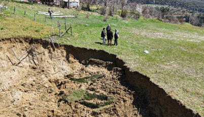
In this practical training activity, students assess landslide damage and its impact on nearby residential areas by using drone technology and analyzing aerial images and videos. Landslides often occur in terrains that are difficult or unsafe to access, especially when slopes are unstable and ground conditions are continuously changing. In such cases, traditional ground-based inspection methods may expose individuals to serious risks, particularly near the edges of failure zones and unstable soil masses.
Drone-based observation enables a safe and non-contact visual assessment of the affected area without the need for direct physical access. During the activity, students learn how to prepare and operate a drone, plan safe flight paths over landslide zones, and capture high-quality visual data. The collected images and videos are then reviewed, classified, and documented to identify key features such as scarp formations, soil displacement, surface cracks, and proximity of damage to residential structures.
High-resolution aerial imagery allows students to clearly observe the extent and pattern of landslide movement, including areas of active failure and zones at risk of further instability. A key objective of the activity is not only to detect visible damage but also to evaluate the level of risk posed to nearby houses, infrastructure, and people. Students are encouraged to interpret visual evidence and relate it to possible causes such as slope geometry, soil conditions, and environmental factors.
Beyond technical skills, the training emphasizes safety awareness, risk assessment, and responsible decision-making in hazard-prone environments. The activity introduces students to the role of drone technology in disaster risk management, highlighting how rapid and accurate damage assessment can support early warning, mitigation planning, and emergency response. By simulating real-world conditions, this training helps students develop critical observation, analysis, and reporting skills essential for professional practice in geotechnical and disaster management fields.