
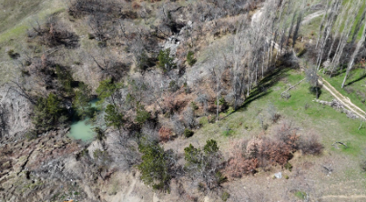
In this practical training activity, students assess the condition of a landslide area by focusing on erosion and scouring processes occurring at the toe of the slope using drone-based visual inspection. In many cases, landslide toe zones are influenced by surface water flow, small streams, or concentrated runoff, which can gradually remove supporting material and contribute to slope instability. Direct access to these areas is often difficult or unsafe due to steep terrain, loose soil, and ongoing ground movement.
Drone technology enables a safe and efficient method to observe landslide toe conditions without physical contact. During the activity, students learn how to plan and execute drone flights over complex terrain, capture high-resolution images of erosion features, and identify key indicators such as undercutting, channel formation, sediment transport, and water accumulation zones. The collected visual data are then organized and interpreted to support a structured site assessment.
High-resolution imagery allows students to clearly observe interactions between the landslide mass and nearby water bodies, including scouring at the slope base and the development of small channels that may accelerate material removal. One of the main objectives of the activity is not only to detect visible erosion features, but also to interpret their role in reducing slope stability and potentially triggering further movement. Students are encouraged to relate observed conditions to possible hydrological and geotechnical processes.
Beyond technical observation skills, the training emphasizes safety awareness, environmental understanding, and analytical thinking. Students develop the ability to evaluate how water-driven processes influence landslide behavior and how early identification of toe erosion can support risk mitigation and decision-making. The activity also highlights the importance of integrating drone-based inspection into post-event assessments and routine monitoring practices. Overall, this exercise prepares students to conduct practical, safe, and informed evaluations of landslide hazards in real-world conditions.