
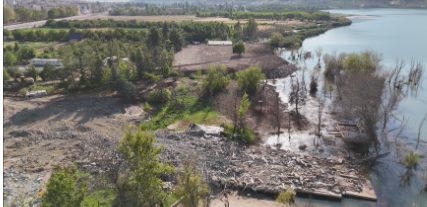
In this practical training activity, students investigate lateral soil displacement that occurs along a lakeshore following an earthquake by using a drone and analyzing the images and videos captured during the flight. After strong ground shaking, especially in areas with soft and water-saturated soils, ground movement may appear in the form of surface cracking, settlement, and soil masses sliding toward the lake. Such areas often become unstable and unsafe, making close-range or ground-based inspection difficult and risky.
Drone technology allows students to carry out a safe, non-contact visual survey of the affected area from above. During the activity, students learn how to prepare and operate the drone, plan safe flight paths, select suitable flight heights and viewing angles, and collect clear visual data. The recorded images and videos are then reviewed, organised, and documented, forming the basis of a simple visual assessment record. This process helps students develop observation, documentation, and communication skills.
High-resolution drone imagery enables students to observe ground deformation patterns efficiently and in detail. These include surface cracks, uneven ground settlement, shoreline retreat, submerged areas, and damage to paths or other built features near the water. One of the main aims of the activity is to help students recognize visible signs of earthquake-related soil movement and to record these observations in a clear, structured, and systematic way. The exercise also demonstrates that drone-based inspection can be effective without the use of advanced software or complex data processing.
Beyond technical learning, the training emphasizes safety, quality, and sustainability, while supporting the development of digital skills, teamwork, responsibility, and independent decision-making. By simulating post-earthquake conditions, the activity introduces students to the role of drone technology in documenting ground hazards and supporting rapid damage assessment. Overall, the exercise prepares students for real-world professional practice by showing how modern digital tools can support faster, safer, and more informed responses to ground instability and environmental hazards after earthquakes.