
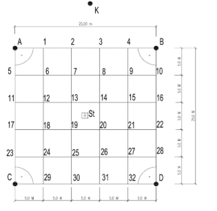
Project-based learning within the subject Professional Practice – Geodesy, focused on Terrain Mapping, is designed to integrate traditional geodetic methods with modern technologies, in particular the use of drones and Global Positioning System (GPS) satellite technologies. The project reflects current trends in contemporary geodetic practice and enables students to work with technologies that are commonly applied in terrain mapping, construction monitoring, and the technical documentation of objects.
The main objective of the project-based learning activity is to develop students’ ability to independently plan, carry out, and evaluate height measurements of objects based on differences in GPS coordinates obtained from drone-assisted data collection. Students become familiar with the principles of determining height and positional relationships within a surveyed area using classical geodetic measurement methods, specifically levelling. Based on measured values, they calculate the height characteristics of the surveyed terrain and subsequently compare these results with elevation data (GPS X, Y, Z coordinates) recorded during drone flights over the area. Through comparison of these datasets, students are able to determine the dimensions of the surveyed area and assess the impact of the applied technologies on measurement accuracy and outcomes.
The project-based approach places emphasis on:
- The use of modern measurement technologies – working with drones and GPS modules, planning flight paths, and collecting spatial data;
- Professional geodetic competences – understanding the principles of coordinate systems, elevation differences, and data processing;
- Analytical and technical thinking – processing measured data, evaluating the accuracy of GPS measurements, and comparing results with classical geodetic methods, particularly levelling;
- Practical skills – maintaining measurement documentation, processing data using specialised software, and producing outputs in the form of tables, graphical representations, and evaluations of results obtained through both classical methods (levelling instruments with subsequent calculations and graphical mapping) and modern methods (drone monitoring and GPS-based photogrammetry);
- Responsibility and work safety – compliance with drone operation regulations, adherence to safety standards, and the protection of people and property during field-based geodetic activities.
Throughout the project, students progress through all stages of geodetic work: from measurement preparation (selection of the surveyed area, drone flight planning, and methodology definition), through the execution of field measurements using drones and GPS and preparation for levelling measurements, to the processing and evaluation of results. The final output of the project is a comprehensive report on the determination of the positional and height parameters of the surveyed area. This report includes a description of the technologies used, the measurement procedures, relevant calculations, and an evaluation of measurement accuracy.
This project-based learning approach supports active learning, increases student motivation, and prepares learners for real-world professional situations in modern geodetic practice, where unmanned aerial systems and digital spatial data play an increasingly significant role.