
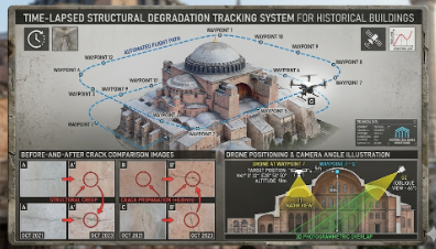
The “Time-Scheduled Waypoint-Based Structural Deterioration Monitoring System for Historical Structures” project is an AI-supported monitoring system designed to periodically capture facade images of historical bridges, towers, and stone structures from the exact same coordinates, altitude, and camera angles. Within the project, the waypoint and route memory capabilities of the DJI Mini 4 Pro drone are utilized to obtain standardized high-resolution images during each flight mission. The collected images are analyzed using computer vision and image processing techniques to detect structural changes such as crack formation, surface deformation, material erosion, and restoration requirements. The system aims to provide a low-cost, contactless, and sustainable digital monitoring solution for preserving historical structures and supporting restoration processes with data-driven analysis.